Customer story: London Borough of Sutton, UK
Transport Planning Process
The bigger picture
The London Borough of Sutton is a local authority that is at the forefront of next-generation engagement with its constituents. The council regularly runs a wide range of surveys and engagement initiatives with diverse groups across the area, something that Citizen Space has been helping them to do successfully for over a decade. To date, Sutton Council have run more than 300 activities on the platform.
Now, with the addition of Citizen Space Geospatial, the council is able to bring a whole new dimension to these activities.
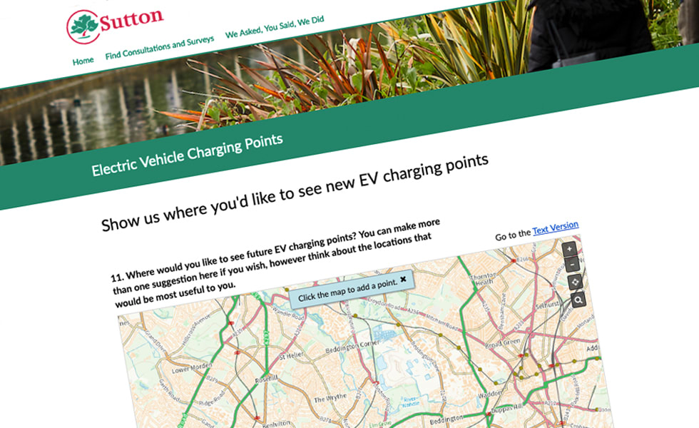
Sutton Council had a number of initiatives where engaging residents using a standard questionnaire approach wasn't enough. When asking locals for their views on where new electric vehicle (EV) charging stations should be installed, for example, written responses or multiple choice answers simply wouldn't give the council the data they required. They needed a more visual solution.
Expanded possibilities
Citizen Space Geospatial provided just such a solution. Sutton Council used Citizen Space Geospatial to add an interactive map to their EV survey, showing residents where existing charging points were located and allowing respondents to drop pins where they wanted to see new ones installed. Whereas before the council might have relied on static, hard to understand diagrams, with the clear and easy to use addition of an interactive map, they were able to get precise responses while also vastly improving the user experience.
Seamlessly integrating a geospatial element into their consultations has allowed Sutton Council to get an even deeper understanding of their constituents' views and is a powerful feature that can be applied to a variety of scenarios, from Local Plans and Calls for Sites to transport planning exercises. In addition to dropping pins, Sutton Council can use Citizen Space Geospatial to ask users to mark out a route on a map (for example to demonstrate a journey to and from school), or to draw a shape to demarcate a specific area, which is particularly useful for zoning consultations and highlighting property boundaries.
Citizen Space Geospatial's multi-layered approach also enables the council to provide respondents with as much or as little detail as they want. And because it's been designed with accessibility and inclusion in mind, people who can't read a map can still get the full picture.
Enhanced engagement
As a long-time user of Citizen Space, Sutton Council were already well aware of its ability to power next-generation consultations. Yet Citizen Space Geospatial is further revolutionising the authority's place-based engagement. The platform is supporting them to generate new ideas, get more specific feedback, and better inform people about their decisions.
Citizen Space Geospatial is helping organisations like Sutton Council to not just visualise the problem, but to visualise the solution as well.
Want a real person to walk you through a live demo?
We’re happy to help out. We'll answer all your questions. We won't share your contact details.
Request a Free Demo